Methods
Water Conservation Areas
Every year, nesting effort is monitored using monthly aerial surveys conducted over 3-4 days mid-month to determine the numbers of nests started in WCAs 1, 2, and 3 during the breeding season (January through June). Aerial monitoring focuses on counts of visible species (Wood Storks, Great Egrets, White Ibis, Snowy Egrets, Great Blue Herons, and Roseate Spoonbills) while only the presence of dark species and under canopy nesters (Little Blue Herons, Tricolored Herons, Black Crowned Night Herons, and Glossy Ibis) and Anhinga are noted if they happen to be observed. Counts of dark or under canopy nesters are not systematic across years but are done when possible. Aerial survey transects have been consistent since 1987 and survey methods have been updated with technology but otherwise consistent. Surveys are conducted in the middle of each month along predefined East-West transects that are spaced 1.6 nautical miles apart, which was determined empirically as the distance whereby naive observers can routinely spot known colonies. Transect locations are made repeatable between years using a stored flight plan that is shared with the pilot and monitored by project personnel in flight. Surveys are flown at 800 feet AGL (above ground level) and are generally flown at ~110-120 knots. Surveys begin at sunrise when most adult wading birds are present in the colonies, and are finished around noon, to coincide with the best sun angle for viewing into vegetated colonies.
![]()
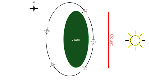
During flights, two observers sit on opposite sides of the plane looking for active wading bird colonies. “White dots” on the green background, and birds obviously flying to and from a single point are visual cues used for colony detections. When a colony is spotted, the plane veers from the transect to circle the colony in a clockwise direction 600-800 feet AGL while visual counts and photos are obtained (Figure 2). Up until 2005, colony counting was sometimes also done as low as 500’ AGL for better viewing conditions. Counts and photos are only made from the east side of the island while flying from north to south in the circle and looking west into the colony to standardize sun position; viewing from the west can decrease the count of white birds by over 50%. Observers estimate numbers of nesting and roosting birds by species and record observations on nest stage, species present, and other details that may be helpful for interpreting colony phenology and numbers of nest starts in photos. Multiple pictures are taken even if an entire colony may be captured in one image. For large colonies, photos are taken systematically down the length of the colony with enough of the edges captured within the images to help with photo stitching later on. Settings such as aperture and exposure are set by the observer with the general goal of obtaining clear photos with varying light and movement conditions. Some zoomed in photos of clumps of birds may also be taken to help with species ID and nesting status. Along with species counts and notes, standardized datasheets record time of takeoff and landing, start and stop time of survey, date, transects covered, names of the observers and the exact set of photo image numbers for each colony so files may be sorted appropriately later. While observer counts are recorded in flight, counting nests in photos has proven to be a more reliable method. From 1986-1987 counts are based solely on aerial observer counts by a single observer. From 1986 - 2000, photos were taken with a Pentax single lens film camera and projected on screens via slides for counting. Digital cameras were adopted in 2009 (Frederick and Simon 2009) and new cameras were bought as technology improved. Cameras used for digital aerial photographs: 2011-2020:Canon EOS 20D, 8.2 megapixel, digital SLR, fitted with Camera lens: Canon EF (electronic focus) 28-135mm 1:3.5-5.6 IS (image stabilizer). 2022-Current: Nikon D850, 45.7 megapixel fitted with AF-S NIKKOR 24-120mm 1.4G ED lens. Both Adobe Photoshop Elements and Microsoft Paint have been used for counting digital photos. Photos are used to count nests and roosting birds for each species. The approach to counting photos has evolved over time with the development of technology and counting aids. Before using digital cameras, film slides were used to project images for counting. If a colony is small, a single image may be used and individual nests are marked and counted. As colony size increases, multiple images are stitched together, either manually, or via photoshop stitching and nests may be counted in groups (5s or 10s of nests). For exceptionally large colonies or blurred imagery, aerial observer estimates are used in place of photos. Manual stitching is the preferred method and birds/landmarks/geography are used to help aid the stitching process. When a nest of eggs or chicks is observed with no adults, this is still counted as a nest. If two adult birds are sitting on the same nest, this is counted as one nest. Some years surveys were disrupted due to logistical issues, funding constraints, or pandemics. 1989-1990 funding limited flights. Middle-Late 1990s, flights were not conducted in the early part of the year though observers also noted limited nesting early in the season. 2020-2021, due to COVID-19 restrictions on social distancing advised by CDC/FDA and implemented by the University of Florida from April 2020 through the 2021 field season, aerial surveys could not be conducted. Drone flights were conducted during that time over as many active colonies as possible, and combined with colony counts from the South Florida Water Management District’s helicopter surveys to generate an estimate of max nest starts. While differences in methodology exist, these estimates were undertaken to produce 2020 and 2021 max counts that were as comparable to previous efforts as possible.
Everglades National Park
We also include maximum nest counts from Everglades National Park. These counts are conducted by the National Park Service and South Florida Water Management District with occasional assistance from our project. Methods are similar between the WCAs and Everglades National Park. See the annual South Florida Wading Bird Report for details.